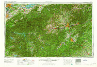
1964 Map of Knoxville
USGS Topo · Published 1964About this map
The Great Smoky Mountains and Blue Ridge Mountains dominate this mid-century landscape, capturing the Southern Appalachians before modern interstate expansion fully reshaped regional travel. Centered on the rugged border between Tennessee and North Carolina, the map highlights a massive network of protected lands, including Great Smoky Mountains National Park and the surrounding Pisgah National Forest.
Find a feature on this map
45 named features on this map. Tap any name to fly to it.
Don’t see what you’re looking for? This feature index may not catch every label — zoom into the map to look around manually.
Map Details
Editions of this 1964 Knoxville Map
This is the sole edition of this map. No revisions or reprints were ever made.
Other maps of this area

1883 · Morristown
USGS Topo · 1:125,000

1886 · Knoxville
USGS Topo · 1:125,000

1886 · Dahlonega
USGS Topo · 1:125,000

1886 · Walhalla
USGS Topo · 1:125,000

1888 · Ellijay
USGS Topo · 1:125,000

1888 · Pickens
USGS Topo · 1:125,000

1891 · Cowee
USGS Topo · 1:125,000

1891 · Roan Mountain
USGS Topo · 1:125,000

1892 · Dahlonega
USGS Topo · 1:125,000

1892 · Walhalla
USGS Topo · 1:125,000