
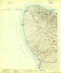
1916 Map of Kohala
USGS Topo · Published 1916About this map
Sugar production and coastal trade dominate this early twentieth-century survey of the northern tip of the Big Island. The industrial backbone of the region is visible through the Hawaii Railway, which connects the vital processing centers at Union Mill, Kohala Mill, and Hoea Mill to the coast. The settlement at Hawi serves as a central hub, while the Kohala Ditch represents the massive engineering efforts required to move water from the windward slopes to the thirsty cane fields of the leeward coast.
Find a feature on this map
52 named features on this map. Tap any name to fly to it.
Don’t see what you’re looking for? This feature index may not catch every label — zoom into the map to look around manually.
Map Details
Editions of this 1916 Kohala Map
2 editions found
Other maps of this area

1913 · Kohala
USGS Topo · 1:62,500

1916 · Waipio
USGS Topo · 1:62,500

1928 · Puako
USGS Topo · 1:62,500

1954 · Hawaii North
USGS Topo · 1:250,000

1956 · Puu Hinai
USGS Topo · 1:24,000

1956 · Kamuela
USGS Topo · 1:24,000

1956 · Nohonaohae
USGS Topo · 1:24,000

1956 · Kawaihae
USGS Topo · 1:24,000
1957 · Keawanui Bay
USGS Topo · 1:24,000
1957 · Honokane
USGS Topo · 1:24,000