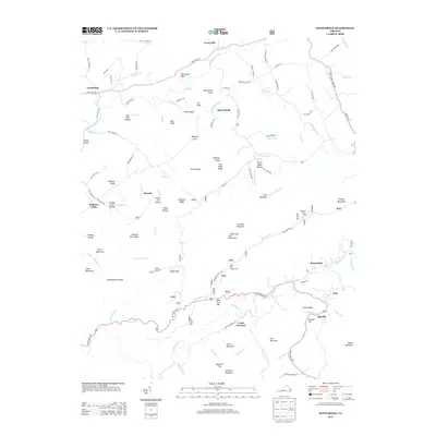
2013 Map of Konnarock
USGS Topo · Published 2013About this map
Konnarock and the surrounding mountain settlements of Washington County define this high-country landscape. The topography is dominated by the Iron Mountains and a series of sharp ridges including Piney Ridge and Feathercamp Ridge. The drainage pattern is complex, with the S Fork Holston River winding through the northern reaches near Loves Mill, while the southern portion is carved by Whitetop Laurel Cr. Notable family-named landmarks like Joe Doss Hollow and Frank Coe Hollow suggest a deeply rooted local history. Public land use is evident through the presence of the Bear Tree Group Camp and Beartree Family Camp. These settlements, including Azen and Creek Junction, are connected by a network of rural roads that navigate the gaps and coves, illustrating the enduring relationship between the terrain and its residents.
Find a feature on this map
131 named features on this map. Tap any name to fly to it.
Don’t see what you’re looking for? This feature index may not catch every label — zoom into the map to look around manually.
Map Details
Editions of this 2013 Konnarock Map
This is the sole edition of this map. No revisions or reprints were ever made.
Other maps of this area

1891 · Abingdon
USGS Topo · 1:125,000

1894 · Abingdon
USGS Topo · 1:125,000

1909 · Abingdon
USGS Topo · 1:96,000

1911 · Abingdon
USGS Topo · 1:125,000

1935 · Konnarock
USGS Topo · 1:24,000

1935 · Chilhowie
USGS Topo · 1:24,000

1935 · Grayson
USGS Topo · 1:24,000

1935 · Park
USGS Topo · 1:24,000

1935 · Mount Rogers
USGS Topo · 1:48,000
1935 · Laurel Bloomery
USGS Topo · 1:24,000