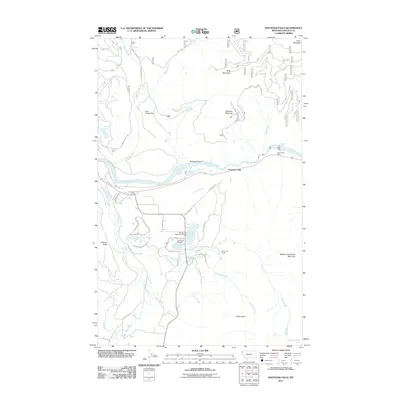
2011 Map of Kootenai Falls
USGS Topo · Published 2011About this map
Kootenai Falls cascades through the heart of this landscape, where the Kootenai River carves a deep path between Kootenai Mountain and William Grambauer Mountain. This 2011 survey by the U.S. Geological Survey shows a geography defined by its water and high peaks, including the expansive Lynx Creek Flats and the heights of King Mountain. To the south, a cluster of lakes including Savage Lake, Milnor Lake, and Throop Lake provides a focal point for local activity near the Savage Lake Sportsmans Access. Residential and recreational footprints are evident at Swansons Lodge and the Lions Picnic Area, while the Larchwood Cemetery and schools along Schoolhouse Lake Rd mark the established community hubs. The intricate network of forest development roads, such as Natl Forest Develop Road 4445 Rd, illustrates the region's managed wilderness and timber heritage.
Find a feature on this map
60 named features on this map. Tap any name to fly to it.
Don’t see what you’re looking for? This feature index may not catch every label — zoom into the map to look around manually.
Map Details
Editions of this 2011 Kootenai Falls Map
This is the sole edition of this map. No revisions or reprints were ever made.
Other maps of this area

1920 · Libby
USGS Topo · 1:125,000

1930 · Libby
USGS Topo · 1:125,000

1932 · Libby
USGS Topo · 1:125,000

1957 · Kalispell
USGS Topo · 1:250,000

1960 · Kalispell
USGS Topo · 1:250,000

1961 · Kalispell
USGS Topo · 1:250,000

1963 · Scenery Mountain
USGS Topo · 1:24,000
1963 · Spar Lake
USGS Topo · 1:24,000

1963 · Turner Mountain
USGS Topo · 1:24,000

1963 · Pulpit Mountain
USGS Topo · 1:24,000