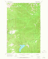
1963 Map of Spar Lake
USGS Topo · Published 1966About this map
Spar Lake anchors the southern portion of this high-elevation landscape, where the Kootenai National Forest and Kaniksu National Forest meet. The 1963 survey illustrates a wilderness defined by steep drainages like North Fork Keeler Creek and South Fork Keeler Creek, with peaks such as Stanley Mountain and Grouse Mountain providing significant vertical relief. Access to the area is primarily via unimproved dirt roads and trails, serving the Spar Lake Campground and early industrial activities indicated by a Mine and Gravel Pit. The map captures a transition in forest management and recreational use, documenting specific family-named and descriptive landmarks like Pony Mountain, Stanley Peak, and Thicket Creek. These detailed hydrological and topographical records offer a clear view of the mountain interior before more modern development altered the remote character of the Lincoln County high country.
Find a feature on this map
32 named features on this map. Tap any name to fly to it.
Don’t see what you’re looking for? This feature index may not catch every label — zoom into the map to look around manually.
Map Details
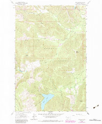
Editions of this 1963 Spar Lake Map
2 editions found
Other maps of this area

1911 · Priest Lake
USGS Topo · 1:250,000

1913 · Priest Lake
USGS Topo · 1:250,000

1920 · Libby
USGS Topo · 1:125,000

1930 · Libby
USGS Topo · 1:125,000

1932 · Libby
USGS Topo · 1:125,000

1951 · Clark Fork
USGS Topo · 1:62,500

1951 · Mt Pend Oreille
USGS Topo · 1:62,500

1957 · Kalispell
USGS Topo · 1:250,000

1958 · Sandpoint
USGS Topo · 1:250,000

1960 · Kalispell
USGS Topo · 1:250,000