
1963 Map of Scenery Mountain
USGS Topo · Published 1966About this map
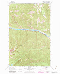
Kootenai National Forest dominates this topographic study of Lincoln County, Montana, where the Great Northern railway follows the winding course of the Kootenai River. The landscape is defined by the sharp verticality of the Cabinet Mountains, reaching peaks at Scenery Mountain and Grambauer Mountain. A Lookout Tower stands atop Scenery Mountain, overlooking a network of narrow drainages including Williams Creek and Cedar Creek. To the southwest, the Cabinet Mountains Wilderness Boundary encloses high-altitude features like Upper Cedar Lake and Lower Cedar Lake. Human activity in this mid-century wilderness is represented by a series of pack trails and a lone Gravel Pit near the riverbank, illustrating an era focused on forestry management and the maintenance of essential transportation corridors through the mountains.
Find a feature on this map
32 named features on this map. Tap any name to fly to it.
Don’t see what you’re looking for? This feature index may not catch every label — zoom into the map to look around manually.
Map Details
Editions of this 1963 Scenery Mountain Map
2 editions found
Other maps of this area

1920 · Libby
USGS Topo · 1:125,000

1930 · Libby
USGS Topo · 1:125,000

1932 · Libby
USGS Topo · 1:125,000

1957 · Kalispell
USGS Topo · 1:250,000

1960 · Kalispell
USGS Topo · 1:250,000

1961 · Kalispell
USGS Topo · 1:250,000

1963 · Turner Mountain
USGS Topo · 1:24,000

1963 · Pulpit Mountain
USGS Topo · 1:24,000

1963 · Treasure Mountain
USGS Topo · 1:24,000
1963 · Crowell Mountain
USGS Topo · 1:24,000