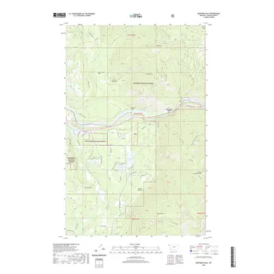
2020 Map of Kootenai Falls
USGS Topo · Published 2020About this map
The Kootenai River carves a deep valley through the northern reaches of the Kootenai National Forest, creating the dramatic cascade known as Kootenai Falls. This region is defined by the sharp rise of the Cabinet Mountains to the south and the Purcell Mountains to the north, with numerous high-altitude water bodies such as Upper Cedar Lake and Shannon Lake dotting the terrain. The presence of the Troy Dam Reservoir indicates the controlled water power of the area, while the route of Historic Highway 2 W traces the primary corridor through this wilderness.
Find a feature on this map
56 named features on this map. Tap any name to fly to it.
Don’t see what you’re looking for? This feature index may not catch every label — zoom into the map to look around manually.
Map Details
Editions of this 2020 Kootenai Falls Map
This is the sole edition of this map. No revisions or reprints were ever made.
Other maps of this area

1920 · Libby
USGS Topo · 1:125,000

1930 · Libby
USGS Topo · 1:125,000

1932 · Libby
USGS Topo · 1:125,000

1957 · Kalispell
USGS Topo · 1:250,000

1960 · Kalispell
USGS Topo · 1:250,000

1961 · Kalispell
USGS Topo · 1:250,000

1963 · Scenery Mountain
USGS Topo · 1:24,000
1963 · Spar Lake
USGS Topo · 1:24,000

1963 · Turner Mountain
USGS Topo · 1:24,000

1963 · Pulpit Mountain
USGS Topo · 1:24,000