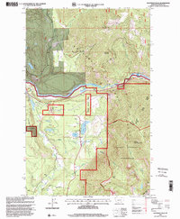
1997 Map of Kootenai Falls
USGS Topo · Published 2000About this map
The Kootenai River carves a dramatic path through the northwest corner of Montana, defining a landscape where industrial utility meets protected wilderness. In the late 20th century, this area shows a complex water management system anchored by the Troy Dam and the Troy City Reservoir, alongside the natural drop of the Kootenai Falls. Local history is centered around the small lakes dotting the valley floor, including Schoolhouse Lake and Milnor Lake, with Larchwood Cem serving as a key genealogical landmark. The eastern portion of the map is dominated by the steep ascent into the Cabinet Mountains Wilderness, reaching heights at William Grambauer Mtn and Taylor Peak. This survey captures the boundary between managed timber lands within the Kootenai National Forest and the preserved high-altitude terrain that has remained largely inaccessible to vehicles.
Find a feature on this map
40 named features on this map. Tap any name to fly to it.
Don’t see what you’re looking for? This feature index may not catch every label — zoom into the map to look around manually.
Map Details
Editions of this 1997 Kootenai Falls Map
This is the sole edition of this map. No revisions or reprints were ever made.
Other maps of this area

1920 · Libby
USGS Topo · 1:125,000

1930 · Libby
USGS Topo · 1:125,000

1932 · Libby
USGS Topo · 1:125,000

1957 · Kalispell
USGS Topo · 1:250,000

1960 · Kalispell
USGS Topo · 1:250,000

1961 · Kalispell
USGS Topo · 1:250,000

1963 · Scenery Mountain
USGS Topo · 1:24,000
1963 · Spar Lake
USGS Topo · 1:24,000

1963 · Turner Mountain
USGS Topo · 1:24,000

1963 · Pulpit Mountain
USGS Topo · 1:24,000