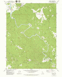
1979 Map of Korbel
USGS Topo · Published 1979About this map
The Mad River dominates this landscape as it flows through the timber and ranch lands of Humboldt County in the late 1970s. The settlement of Korbel serves as a focal point near the confluence with the North Fork Mad River, while industrial activity is noted at the Mad River Fish Hatchery and several gravel pits and quarries along the water. The map documents a distinct pattern of high-altitude clearings, or prairies, such as Boynton Prairie, Garner Prairie, and Diamond Prairie, which break up the forested slopes of Fickle Hill and Boundary Hill.
Find a feature on this map
46 named features on this map. Tap any name to fly to it.
Don’t see what you’re looking for? This feature index may not catch every label — zoom into the map to look around manually.
Map Details
Editions of this 1979 Korbel Map
This is the sole edition of this map. No revisions or reprints were ever made.
Other maps of this area

1922 · Eureka
USGS Topo · 1:62,500

1922 · Korbel
USGS Topo · 1:62,500

1922 · Kneeland
USGS Topo · 1:62,500

1933 · Eureka
USGS Topo · 1:48,000

1942 · Eureka
USGS Topo · 1:62,500

1944 · Fortuna
USGS Topo · 1:62,500

1945 · Blue Lake
USGS Topo · 1:62,500

1949 · Eureka
USGS Topo · 1:250,000

1950 · Iaqua Buttes
USGS Topo · 1:62,500

1951 · Eureka
USGS Topo · 1:62,500