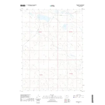
2017 Map of Koshopah NE
USGS Topo · Published 2017About this map
Willow Lake dominates the northern reaches of this Nebraska Sandhills landscape, situated within a topography defined by low-lying wetlands and seasonal water bodies. This 2017 survey by the U.S. Geological Survey captures a sparsely settled portion of Brown County where the primary human infrastructure consists of Elsmere Rd, which winds through the western and northern sections. The map reveals the intricate drainage patterns and hydrological features of the region, including Diamond Lake and the clustered Chain Lakes. These features represent the unique high-plains geography of the Loup River drainage area, where the intersection of the Ogallala Aquifer and surface depressions creates a network of alkaline and freshwater lakes vital to local ranching and wildlife.
Find a feature on this map
8 named features on this map. Tap any name to fly to it.
Don’t see what you’re looking for? This feature index may not catch every label — zoom into the map to look around manually.
Map Details
Editions of this 2017 Koshopah NE Map
This is the sole edition of this map. No revisions or reprints were ever made.
Other maps of this area

1949 · Koshopah
USGS Topo · 1:62,500

1951 · Moon Lake
USGS Topo · 1:62,500

1951 · Koshopah
USGS Topo · 1:62,500

1955 · O'Neill
USGS Topo · 1:250,000

1957 · Valentine
USGS Topo · 1:250,000

1959 · Valentine
USGS Topo · 1:250,000

1959 · O'Neill
USGS Topo · 1:250,000

1969 · O'Neill
USGS Topo · 1:250,000
1982 · Goldman Lake NW
USGS Topo · 1:24,000
1982 · Raven SW
USGS Topo · 1:24,000