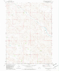
1982 Map of Goldman Lake NW
USGS Topo · Published 1982About this map
The Calamus River meanders through this portion of Brown County, defining a landscape dominated by large-scale cattle ranching operations in the early 1980s. The settlement pattern is sparse, consisting almost entirely of named family ranch holdings that serve as the primary landmarks in this sandhills environment. Genealogists and local historians can locate specific property sites such as Hollopeter Ranch in the north and the Einspahr Ranch to the south. The mapping shows an economy built on the water resources of the river and scattered wells, with a solitary Claypit in the southeast corner indicating a small-scale extractive industrial use amidst the grazing land. This era represents a time when traditional family-named ranches like Hitchcock Ranch and Pixley Ranch remained the focal points of the rural Nebraska interior.
Find a feature on this map
14 named features on this map. Tap any name to fly to it.
Don’t see what you’re looking for? This feature index may not catch every label — zoom into the map to look around manually.
Map Details
Editions of this 1982 Goldman Lake NW Map
This is the sole edition of this map. No revisions or reprints were ever made.
Other maps of this area

1949 · Koshopah
USGS Topo · 1:62,500

1951 · Moon Lake
USGS Topo · 1:62,500

1951 · Koshopah
USGS Topo · 1:62,500

1955 · O'Neill
USGS Topo · 1:250,000

1957 · Valentine
USGS Topo · 1:250,000

1959 · Valentine
USGS Topo · 1:250,000

1959 · O'Neill
USGS Topo · 1:250,000

1969 · O'Neill
USGS Topo · 1:250,000

1982 · Raven
USGS Topo · 1:24,000
1982 · Goldman Lake SE
USGS Topo · 1:24,000