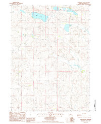
1986 Map of Koshopah NE
USGS Topo · Published 1986About this map
Willow Lake and the Chain Lakes anchor this mid-1980s topographic record of the Nebraska Sandhills. The landscape is defined by its hydrology and sparse infrastructure, centered near the locality of Koshopah. A network of unimproved roads and a specific Private Road navigate the undulating Sand terrain, which is otherwise marked only by occasional windmills and a primary Trans Line. The presence of a Flowing Well near the northern boundary highlights the region's relationship with the underlying aquifer, essential for cattle ranching in this portion of Brown County. This 1986 provisional edition reflects a moment before significant modern changes, preserving the locations of remote homesteads and access points used during the late 20th century.
Find a feature on this map
9 named features on this map. Tap any name to fly to it.
Don’t see what you’re looking for? This feature index may not catch every label — zoom into the map to look around manually.
Map Details
Editions of this 1986 Koshopah NE Map
This is the sole edition of this map. No revisions or reprints were ever made.
Other maps of this area

1949 · Koshopah
USGS Topo · 1:62,500

1951 · Moon Lake
USGS Topo · 1:62,500

1951 · Koshopah
USGS Topo · 1:62,500

1955 · O'Neill
USGS Topo · 1:250,000

1957 · Valentine
USGS Topo · 1:250,000

1959 · Valentine
USGS Topo · 1:250,000

1959 · O'Neill
USGS Topo · 1:250,000

1969 · O'Neill
USGS Topo · 1:250,000
1982 · Goldman Lake NW
USGS Topo · 1:24,000
1982 · Raven SW
USGS Topo · 1:24,000