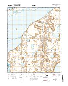
2014 Map of Kotzebue B-6 NW
USGS Topo · Published 2014About this map
Bering Land Bridge National Preserve dominates this coastal landscape, protecting a vast stretch of Arctic tundra and shifting waterways where the ancient land bridge once connected continents. The map details a complex hydrologic network where the Singeakpuk River and Cowpack River meander through low-lying plains toward the Chukchi Sea. The interaction between the freshwater systems and the brackish reaches of Shishmaref Inlet and Cowpack Inlet creates a dynamic environment of lagoons and seasonal wetlands. Inland, features like White Fish Lake emphasize the importance of the local hydrography to the ecosystem. A single primitive route, the Inlet Bypass, cuts across the terrain, indicating the minimal human infrastructure and the reliance on seasonal trails for movement through this remote Seward Peninsula region.
Find a feature on this map
14 named features on this map. Tap any name to fly to it.
Don’t see what you’re looking for? This feature index may not catch every label — zoom into the map to look around manually.
Map Details
Editions of this 2014 Kotzebue B-6 NW Map
This is the sole edition of this map. No revisions or reprints were ever made.
Other maps of this area

1950 · Kotzebue C-6
USGS Topo · 1:63,360

1950 · Shishmaref
USGS Topo · 1:250,000

1950 · Shishmaref B-1
USGS Topo · 1:63,360

1950 · Kotzebue B-6
USGS Topo · 1:63,360

1951 · Shishmaref
USGS Topo · 1:250,000

1951 · Kotzebue
USGS Topo · 1:250,000

1958 · Kotzebue
USGS Topo · 1:250,000

1964 · Kotzebue
USGS Topo · 1:250,000
2014 · Kotzebue B-6 NE
USGS Topo · 1:25,000
2014 · Kotzebue B-6 SW
USGS Topo · 1:25,000