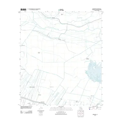
2012 Map of Kraemer
USGS Topo · Published 2012About this map
Melodia Plantation and the historic ribbon settlements along Bayou Lafourche anchor this portion of the Louisiana bayou country. The map documents the intricate network of water and land, where linear settlements like Rousseau, Saint Charles, and Ewing follow the natural levees. The interior landscape is dominated by an extensive system of drainage and navigation canals, including the Laurel Valley Canal and Halpin Canal, which carve through the wetlands toward Lake Boeuf. Industrial activity is evident throughout the marshlands, with the Melodia Gas Field and Northwest Lake Boeuf Oil and Gas Field appearing alongside traditional rural settlements. The northern reaches show the community of Kraemer situated among winding waterways like Bayou L'Ours and Grand Bayou, illustrating the enduring relationship between the local population and the volatile hydrology of the Deltaic Plain.
Find a feature on this map
48 named features on this map. Tap any name to fly to it.
Don’t see what you’re looking for? This feature index may not catch every label — zoom into the map to look around manually.
Map Details
Editions of this 2012 Kraemer Map
This is the sole edition of this map. No revisions or reprints were ever made.
Other maps of this area

1892 · Lac Des Allemands
USGS Topo · 1:62,500

1892 · Gibson
USGS Topo · 1:62,500

1892 · Houma
USGS Topo · 1:62,500

1892 · Thibodaux
USGS Topo · 1:62,500

1897 · Gibson
USGS Topo · 1:62,500

1932 · Lac Des Allemands NW
USGS Topo · 1:31,680

1932 · Lac Des Allemands SE
USGS Topo · 1:31,680

1932 · Lac Des Allemands SW
USGS Topo · 1:31,680

1932 · Houma NE
USGS Topo · 1:31,680

1932 · Thibodaux NE
USGS Topo · 1:31,680