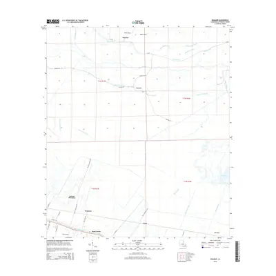
2015 Map of Kraemer
USGS Topo · Published 2015About this map
Melodia Plantation and the surrounding agricultural tracts define this 2015 layout of the Louisiana lowlands, where the land-water boundary is perpetually blurred. The landscape is structured by a network of drainage channels and historic routes, including the Laurel Valley Canal and Halpin Canal, which support the sugar and rice heritage of the Lafourche Parish region. Small settlements like Kraemer and Choctaw sit north of the major waterway of Bayou Lafourche, while names like Saint Charles and Rousseau line the southern corridor along Highway 308. The map demonstrates the unique hydrology of the area, featuring Lake Boeuf and a complex system of bayous such as Grand Bayou and Bayou L'Ours. For researchers, these modern surveys preserve the names of plantation-era roads like Ariel Plantation Rd and Melodia Plantation Rd, tracing the evolution of family lands into the current century.
Find a feature on this map
41 named features on this map. Tap any name to fly to it.
Don’t see what you’re looking for? This feature index may not catch every label — zoom into the map to look around manually.
Map Details
Editions of this 2015 Kraemer Map
This is the sole edition of this map. No revisions or reprints were ever made.
Other maps of this area

1892 · Lac Des Allemands
USGS Topo · 1:62,500

1892 · Gibson
USGS Topo · 1:62,500

1892 · Houma
USGS Topo · 1:62,500

1892 · Thibodaux
USGS Topo · 1:62,500

1897 · Gibson
USGS Topo · 1:62,500

1932 · Lac Des Allemands NW
USGS Topo · 1:31,680

1932 · Lac Des Allemands SE
USGS Topo · 1:31,680

1932 · Lac Des Allemands SW
USGS Topo · 1:31,680

1932 · Houma NE
USGS Topo · 1:31,680

1932 · Thibodaux NE
USGS Topo · 1:31,680