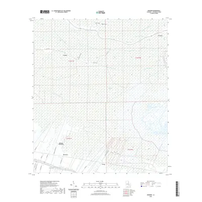
2020 Map of Kraemer
USGS Topo · Published 2020About this map
Bayou Lafourche anchors the southern boundary of this Louisiana landscape, where the transition from agricultural plantation lands to the deep wetlands of the Rathborne Swamp is clearly visible. The map documents a classic South Louisiana settlement pattern, with communities like Rousseau, Ewing, and Melodia Plantation clustered near the bayou's natural levee while narrow roads like Ariel Plantation Rd and Bush Grove Rd extend into the surrounding fields. Further north, the dense hydrologic network of Grand Bayou, Bayou Ours, and the Pitré-Bening Canal defines the wilderness between Choctaw and Kraemer. These waterways, including the winding Bayou Jean Webre and Bayou Rond Pompon, illustrate the complex drainage systems essential to life and industry in Lafourche Parish, showing how man-made canals and natural bayous coexist in this water-dominated environment.
Find a feature on this map
37 named features on this map. Tap any name to fly to it.
Don’t see what you’re looking for? This feature index may not catch every label — zoom into the map to look around manually.
Map Details
Editions of this 2020 Kraemer Map
This is the sole edition of this map. No revisions or reprints were ever made.
Other maps of this area

1892 · Lac Des Allemands
USGS Topo · 1:62,500

1892 · Gibson
USGS Topo · 1:62,500

1892 · Houma
USGS Topo · 1:62,500

1892 · Thibodaux
USGS Topo · 1:62,500

1897 · Gibson
USGS Topo · 1:62,500

1932 · Lac Des Allemands NW
USGS Topo · 1:31,680

1932 · Lac Des Allemands SE
USGS Topo · 1:31,680

1932 · Lac Des Allemands SW
USGS Topo · 1:31,680

1932 · Houma NE
USGS Topo · 1:31,680

1932 · Thibodaux NE
USGS Topo · 1:31,680