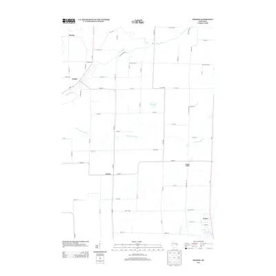
2013 Map of Krakow
USGS Topo · Published 2013About this map
The Oconto River winds through the northwestern corner of this landscape, passing the small clusters of Mosling and Pulcifer as it flows toward the Green Bay watershed. This 2013 survey of northeastern Wisconsin illustrates a patchwork of agricultural plots and rural residential grids, tied together by a network of local connectors such as Co Hwy-C and Co Hwy-E. In the southern portion of the sheet, the settlement of Advance sits at a crossroads, while Krakow occupies the southeastern corner near the Pensaukee River. The terrain is defined by low-lying waterways including the N Br Pensaukee River and Mud Lake, which break up the geometric field patterns. Local family and place names are preserved in the road network, from Larsen Ln and Wahl Rd to the distinctive Holy Hill Rd and Old Highway 22.
Find a feature on this map
56 named features on this map. Tap any name to fly to it.
Don’t see what you’re looking for? This feature index may not catch every label — zoom into the map to look around manually.
Map Details
Editions of this 2013 Krakow Map
This is the sole edition of this map. No revisions or reprints were ever made.
Other maps of this area

1954 · Green Bay
USGS Topo · 1:62,500

1955 · Seymour
USGS Topo · 1:62,500

1955 · Green Bay
USGS Topo · 1:250,000

1956 · Gillett
USGS Topo · 1:62,500

1956 · Oconto Falls
USGS Topo · 1:62,500

1974 · Cecil
USGS Topo · 1:24,000
1974 · Oconto Falls North
USGS Topo · 1:24,000
1974 · Gillett
USGS Topo · 1:24,000
1974 · Berry Lake
USGS Topo · 1:24,000

1974 · Zachow
USGS Topo · 1:24,000