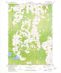
1974 Map of Berry Lake
USGS Topo · Published 1977About this map
The Oconto River winds through this Oconto County landscape, defining the transition between the rolling woodlands and the eastern boundary of the Menominee Indian Reservation. In the mid-1970s, the village of Suring stands as a primary hub in the northeast, supported by infrastructure like a local sewage disposal plant and nearby Radio Towers. The area is characterized by a high density of named country roads and small family-associated landmarks, reflecting a community rooted in timber and agriculture.
Find a feature on this map
35 named features on this map. Tap any name to fly to it.
Don’t see what you’re looking for? This feature index may not catch every label — zoom into the map to look around manually.
Map Details
Editions of this 1974 Berry Lake Map
This is the sole edition of this map. No revisions or reprints were ever made.
Other maps of this area

1942 · Breed
USGS Topo · 1:48,000

1952 · Langlade
USGS Topo · 1:48,000

1952 · Mountain
USGS Topo · 1:48,000

1954 · Shawano
USGS Topo · 1:48,000

1954 · Iron Mountain
USGS Topo · 1:250,000

1955 · Green Bay
USGS Topo · 1:250,000

1956 · Gillett
USGS Topo · 1:62,500

1959 · Iron Mountain
USGS Topo · 1:250,000

1964 · Shawano
USGS Topo · 1:62,500
1973 · Hickory Corners
USGS Topo · 1:24,000