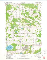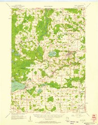
1956 Map of Gillett
USGS Topo · Published 1957About this map
The Chicago and North Western railroad forms a vital transport spine through this mid-century Wisconsin landscape, connecting the agricultural communities of Gillett and Suring. To the west, the eastern boundary of the Menominee Indian Reservation marks a sharp transition in land use, where dense woodland meets the organized grids of dairy country. This era shows a high density of one-room rural institutions, many of which were nearing the end of their service life, such as the Valley Line Sch (Abandoned). Local life centers on the Oconto River and smaller hamlets like Hintz, Mosling, and Cecil, the latter situated on the northeastern shore of Shawano Lake. Genealogists will find a wealth of family-named landmarks and cemeteries, including Puleifer Cem and Tracy Corners Cem, while the presence of the Old Railroad Grade near Newton Lake hints at earlier patterns of the regional timber industry.
Find a feature on this map
107 named features on this map. Tap any name to fly to it.
Don’t see what you’re looking for? This feature index may not catch every label — zoom into the map to look around manually.
Map Details
Editions of this 1956 Gillett Map
This is the sole edition of this map. No revisions or reprints were ever made.
Historical Maps of Chase Through Time
7 maps found