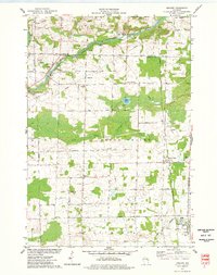
1974 Map of Krakow
USGS Topo · Published 1977About this map
Agricultural lands and dense woodland define the landscape along the border of Oconto and Shawano Counties during the mid-1970s. The Oconto River cuts through the northern reach of the survey, where Rapids and a Gaging Station indicate the active waterway. Small rural centers like Krakow and Green Valley anchor the rail corridor of the Chicago and North Western railroad, which served as a primary transportation artery for the region's dairy and timber output.
Find a feature on this map
53 named features on this map. Tap any name to fly to it.
Don’t see what you’re looking for? This feature index may not catch every label — zoom into the map to look around manually.
Map Details
Editions of this 1974 Krakow Map
This is the sole edition of this map. No revisions or reprints were ever made.
Other maps of this area

1954 · Green Bay
USGS Topo · 1:62,500

1955 · Seymour
USGS Topo · 1:62,500

1955 · Green Bay
USGS Topo · 1:250,000

1956 · Gillett
USGS Topo · 1:62,500

1956 · Oconto Falls
USGS Topo · 1:62,500

1974 · Cecil
USGS Topo · 1:24,000
1974 · Oconto Falls North
USGS Topo · 1:24,000
1974 · Gillett
USGS Topo · 1:24,000
1974 · Berry Lake
USGS Topo · 1:24,000

1974 · Zachow
USGS Topo · 1:24,000