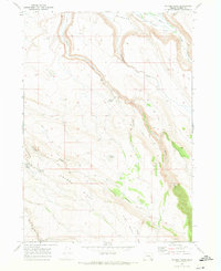
1968 Map of Krumbo Ridge
USGS Topo · Published 1972About this map
Malheur National Wildlife Refuge boundaries overlap the western edges of this topographic study, where the high desert terrain of Harney County transitions into the southern end of Diamond Valley. The landscape is dominated by the massive landform of Krumbo Ridge, a prominent feature that directs the drainage of several seasonal and perennial waterways. A network of primitive transit routes, including Moon Hill Road and various unnamed Jeep Trails, navigates the complex contouring between Krumbo Butte and the surrounding drainages. Water sources are critical in this arid environment, evidenced by the naming of remote points such as Ruby Springs, Krumbo Springs, and the aptly named Hidden Seep. The map details the hydrological system of the region, tracing the paths of McCoy Creek, Cucamonga Creek, and Krumbo Creek as they carve through the high-elevation volcanic plateau.
Find a feature on this map
18 named features on this map. Tap any name to fly to it.
Don’t see what you’re looking for? This feature index may not catch every label — zoom into the map to look around manually.
Map Details
Editions of this 1968 Krumbo Ridge Map
2 editions found
Other maps of this area

1955 · Burns
USGS Topo · 1:250,000

1955 · Adel
USGS Topo · 1:250,000

1957 · Adel
USGS Topo · 1:250,000

1958 · Burns
USGS Topo · 1:250,000

1958 · Adel
USGS Topo · 1:250,000

1959 · Burns
USGS Topo · 1:250,000

1962 · Adel
USGS Topo · 1:250,000

1967 · Happy Valley
USGS Topo · 1:24,000

1967 · Krumbo Reservoir
USGS Topo · 1:24,000
1967 · Diamond Swamp
USGS Topo · 1:24,000