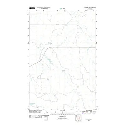
2011 Map of Kuester Lake
USGS Topo · Published 2011About this map
Water management dominates the remote landscape of Richland County, where a network of small earthen dams and reservoirs supports the agricultural needs of Eastern Montana. The namesake Kuester Lake and its associated Kuester Dam sit at the geographic center of this quadrangle, flanked by numerous smaller impoundments including Bank Dam and the curiously named Yodeling Valley Dam.
Find a feature on this map
12 named features on this map. Tap any name to fly to it.
Don’t see what you’re looking for? This feature index may not catch every label — zoom into the map to look around manually.
Map Details
Editions of this 2011 Kuester Lake Map
This is the sole edition of this map. No revisions or reprints were ever made.
Other maps of this area

1909 · Glendive
USGS Topo · 1:250,000

1954 · Glendive
USGS Topo · 1:250,000

1957 · Glendive
USGS Topo · 1:250,000

1958 · Glendive
USGS Topo · 1:250,000

1972 · Clay Butte
USGS Topo · 1:24,000

1972 · Enid SE
USGS Topo · 1:24,000

1972 · Kuester Lake
USGS Topo · 1:24,000

1972 · Enid
USGS Topo · 1:24,000

1981 · Sidney
USGS Topo · 1:100,000
1983 · Carda Coulee
USGS Topo · 1:24,000