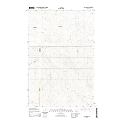
2014 Map of Kuester Lake
USGS Topo · Published 2014About this map
Kuester Lake sits at the center of this 2014 survey, highlighting a pocket of the eastern Montana plains where water management is central to the landscape. Located along the boundary of Dawson and Richland counties, the area is defined by the ephemeral drainages of the Missouri River watershed. Landowners and surveyors will note the presence of Wold Reservoir to the southwest and the winding paths of E Redwater Cr and S Fork Lisk Cr. The transportation network is anchored by Mt-200, which cuts an east-west path across the northern half of the quadrangle, connected by local routes like Cr-126 and CO Road 315. The map reflects a modern rural landscape primarily shaped by topography and the township-and-range surveying system, spanning Township 23 North, Range 53 East and surrounding sections.
Find a feature on this map
12 named features on this map. Tap any name to fly to it.
Don’t see what you’re looking for? This feature index may not catch every label — zoom into the map to look around manually.
Map Details
Editions of this 2014 Kuester Lake Map
This is the sole edition of this map. No revisions or reprints were ever made.
Other maps of this area

1909 · Glendive
USGS Topo · 1:250,000

1954 · Glendive
USGS Topo · 1:250,000

1957 · Glendive
USGS Topo · 1:250,000

1958 · Glendive
USGS Topo · 1:250,000

1972 · Clay Butte
USGS Topo · 1:24,000

1972 · Enid SE
USGS Topo · 1:24,000

1972 · Kuester Lake
USGS Topo · 1:24,000

1972 · Enid
USGS Topo · 1:24,000

1981 · Sidney
USGS Topo · 1:100,000
1983 · Carda Coulee
USGS Topo · 1:24,000