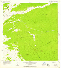
1956 Map of Kulani
USGS Topo · Published 1957About this map
Recent geological activity on the slopes of Mauna Loa is clearly defined by the Lava Flow of 1852 and the Lava Flow of 1942, which cut wide swaths across the island's interior. This high-elevation terrain is characterized by massive forest reserves, including the Upper Waiakea Forest Reserve and the Kilauea Forest Reserve, where human infrastructure is limited to specialized camps and water catchment systems. The Kulani Project stands as a focal point of development in this remote area, connected to the outside world by the Stainback Highway.
Find a feature on this map
36 named features on this map. Tap any name to fly to it.
Don’t see what you’re looking for? This feature index may not catch every label — zoom into the map to look around manually.
Map Details
Editions of this 1956 Kulani Map
This is the sole edition of this map. No revisions or reprints were ever made.
Other maps of this area

1917 · Hilo
USGS Topo · 1:62,500

1921 · Kilauea
USGS Topo · 1:62,500

1922 · Puna
USGS Topo · 1:62,500

1924 · Kilauea
USGS Topo · 1:62,500

1924 · Puna
USGS Topo · 1:62,500

1930 · Humuula
USGS Topo · 1:62,500

1932 · Hilo
USGS Topo · 1:62,500

1954 · Hawaii South
USGS Topo · 1:250,000

1954 · Hawaii North
USGS Topo · 1:250,000

1956 · Puu Oo
USGS Topo · 1:24,000