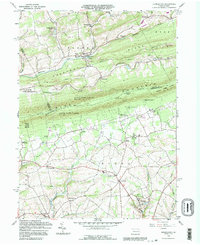
1992 Map of Kunkletown
USGS Topo · Published 1995About this map
Chestnut Ridge and the formidable Blue Mountain dominate the topography here, bisected by the Appalachian Trail at Smiths Gap. The landscape transitions from the ridges of Eldred and Ross townships in the north to the fertile valleys of Moore in the south. This area is characterized by a mix of early industry and established rural communities. Scattered Quarries, Claypits, and Sand and Clay Pits near Kunkletown point to the extraction of local minerals that once supported the regional economy.
Find a feature on this map
54 named features on this map. Tap any name to fly to it.
Don’t see what you’re looking for? This feature index may not catch every label — zoom into the map to look around manually.
Map Details
Editions of this 1992 Kunkletown Map
This is the sole edition of this map. No revisions or reprints were ever made.
Other maps of this area

1894 · Allentown
USGS Topo · 1:62,500

1902 · Slatington
USGS Topo · 1:62,500

1914 · Wind Gap
USGS Topo · 1:62,500

1916 · Wind Gap
USGS Topo · 1:62,500

1922 · Mauch Chunk
USGS Topo · 1:62,500

1924 · Mauch Chunk
USGS Topo · 1:62,500

1937 · Allentown West
USGS Topo · 1:48,000

1939 · Allentown
USGS Topo · 1:62,500

1942 · Allentown West
USGS Topo · 1:62,500

1943 · Mauch Chunk
USGS Topo · 1:62,500
Featured Places
- Chapman, Moore Township
- Eldred Township, PA
- Lehigh Township, PA
- Crossroads, Moore Township
- Moore Township, PA