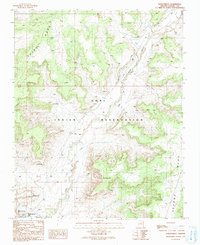
1991 Map of Kykotsmovi
USGS Topo · Published 1991About this map
The Hopi Indian Reservation landscape is defined by the high, flat-topped silhouettes of Third Mesa and Second Mesa during the early 1990s. This survey, based on 1986 field checks, centers on the village of Kykotsmovi and its surrounding ancestral lands. The settlement pattern follows the geography of the mesas, with several named locations such as Songotuyka, Antuyka, and Mungyaovi clustered near the elevated rims or the base of the cliffs.
Find a feature on this map
16 named features on this map. Tap any name to fly to it.
Don’t see what you’re looking for? This feature index may not catch every label — zoom into the map to look around manually.
Map Details
Editions of this 1991 Kykotsmovi Map
This is the sole edition of this map. No revisions or reprints were ever made.
Other maps of this area

1883 · Marsh Pass
USGS Topo · 1:250,000

1883 · Tusayan
USGS Topo · 1:250,000

1886 · Tusayan
USGS Topo · 1:250,000

1892 · Marsh Pass
USGS Topo · 1:250,000

1947 · Flagstaff
USGS Topo · 1:250,000

1954 · Flagstaff
USGS Topo · 1:250,000

1956 · Marble Canyon
USGS Topo · 1:250,000

1958 · Flagstaff
USGS Topo · 1:250,000

1959 · Marble Canyon
USGS Topo · 1:250,000

1960 · Flagstaff
USGS Topo · 1:250,000