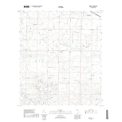
2018 Map of Kynesville
USGS Topo · Published 2018About this map
Kynesville anchors this part of Jackson County, where a complex network of springs and sinks characterizes the limestone-rich Florida Panhandle. The landscape is defined by its water, from the clusters of Bonnet Sink, Woman Sink, and Mule Sink to the perennial flow of Dry Creek and Foxworth Mill Cr. Small, family-named landmarks and rural burial grounds like McCormick Cem and Victory Cem offer important points of reference for local family history and genealogy.
Find a feature on this map
150 named features on this map. Tap any name to fly to it.
Don’t see what you’re looking for? This feature index may not catch every label — zoom into the map to look around manually.
Map Details
Editions of this 2018 Kynesville Map
This is the sole edition of this map. No revisions or reprints were ever made.
Other maps of this area

1952 · Oakdale
USGS Topo · 1:24,000

1952 · Kynesville
USGS Topo · 1:24,000

1952 · Alford SE
USGS Topo · 1:24,000

1952 · Altha West
USGS Topo · 1:24,000

1952 · Cottondale East
USGS Topo · 1:24,000

1952 · Cottondale West
USGS Topo · 1:24,000
1952 · Compass Lake
USGS Topo · 1:24,000
1952 · Alford
USGS Topo · 1:24,000

1952 · Marianna
USGS Topo · 1:24,000

1954 · Tallahassee
USGS Topo · 1:250,000