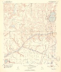
1952 Map of Compass Lake
USGS Topo · Published 1953About this map
Compass Lake serves as a central landmark in this 1952 topographic study of the Florida Panhandle, where the boundaries of Jackson, Washington, and Bay counties converge. The Atlanta and St Andrews Bay railroad line tracks along the eastern side of the lake, connecting the lakeside community with the settlement of Betts to the south. This era of development is evidenced by a road marked as under construction and the presence of a localized Airfield near the tracks.
Find a feature on this map
26 named features on this map. Tap any name to fly to it.
Don’t see what you’re looking for? This feature index may not catch every label — zoom into the map to look around manually.
Map Details
Editions of this 1952 Compass Lake Map
3 editions found
Other maps of this area

1944 · Bennett
USGS Topo · 1:24,000

1945 · Juniper Creek
USGS Topo · 1:31,680

1945 · Bennett
USGS Topo · 1:31,680

1945 · Fountain
USGS Topo · 1:31,680

1950 · Wausau
USGS Topo · 1:24,000

1950 · Gap Lake
USGS Topo · 1:24,000

1951 · Wausau
USGS Topo · 1:24,000

1951 · Gap Pond
USGS Topo · 1:24,000

1952 · Kynesville
USGS Topo · 1:24,000

1952 · Alford SE
USGS Topo · 1:24,000