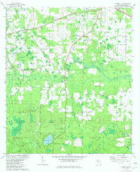
1982 Map of Kynesville
USGS Topo · Published 1982About this map
Kynesville and the surrounding Jackson County landscape appear here as a patchwork of small communities and rural congregations in the early 1980s. The region is defined by a distinct karst topography, where numerous sinks and ponds like Blue Sink, Mule Sink, and Taylor Hole dot the terrain. The presence of several family-named and local landmarks, such as McCormick Lake and Lee and McCormick Ch, suggests a deep-rooted social fabric tied to the land. Settlement patterns follow the high ground near Five Point, while the southern portion of the map transitions toward the Compass Lake Hills. Waterways such as Dry Creek and Stump Creek provide drainage through low-lying areas like Shores Swamp and Victory Swamp. For the family historian, the map identifies several local burial grounds and places of worship, including Damascus Ch Cem, New Salem Ch, and Hickory Level Ch.
Find a feature on this map
47 named features on this map. Tap any name to fly to it.
Don’t see what you’re looking for? This feature index may not catch every label — zoom into the map to look around manually.
Map Details
Editions of this 1982 Kynesville Map
This is the sole edition of this map. No revisions or reprints were ever made.
Other maps of this area

1952 · Oakdale
USGS Topo · 1:24,000

1952 · Kynesville
USGS Topo · 1:24,000

1952 · Alford SE
USGS Topo · 1:24,000

1952 · Altha West
USGS Topo · 1:24,000

1952 · Cottondale East
USGS Topo · 1:24,000

1952 · Cottondale West
USGS Topo · 1:24,000
1952 · Compass Lake
USGS Topo · 1:24,000
1952 · Alford
USGS Topo · 1:24,000

1952 · Marianna
USGS Topo · 1:24,000

1954 · Tallahassee
USGS Topo · 1:250,000