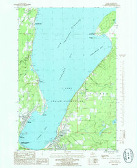
1985 Map of L'Anse
USGS Topo · Published 1985About this map
The L'Anse Indian Reservation dominates this mid-1980s landscape at the foot of Keweenaw Bay, showing the geographic relationship between the mission community at Assinins and the established settlements of Baraga and L'Anse. The map documents the industrial and maritime character of the shoreline, from the mills and piers of the Pequaming peninsula to the Soo Line rail infrastructure and the log storage areas near Pequaming Point.
Find a feature on this map
33 named features on this map. Tap any name to fly to it.
Don’t see what you’re looking for? This feature index may not catch every label — zoom into the map to look around manually.
Map Details
Editions of this 1985 L'Anse Map
This is the sole edition of this map. No revisions or reprints were ever made.
Other maps of this area

1954 · Keweenaw Bay
USGS Topo · 1:62,500

1954 · Pelkie
USGS Topo · 1:62,500

1954 · Sidnaw
USGS Topo · 1:62,500

1955 · Herman
USGS Topo · 1:62,500

1958 · Iron River
USGS Topo · 1:250,000

1960 · Iron River
USGS Topo · 1:250,000

1961 · Iron River
USGS Topo · 1:250,000

1967 · Iron River
USGS Topo · 1:250,000
1984 · Aura
USGS Topo · 1:24,000
1984 · Portage Entry
USGS Topo · 1:24,000