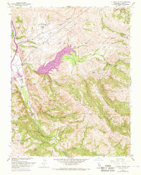
1968 Map of La Costa Valley
USGS Topo · Published 1969About this map
The Vallecitos Atomic Laboratory stands as a prominent technological landmark in this 1968 landscape, positioned north of the San Antonio Reservoir. This survey captures the complex infrastructure of the era, notably the path of the Hetch Hetchy Aqueduct and the Southern Pacific railroad lines that parallel the Arroyo de la Laguna. The geography is defined by the steep transitions between Sunol Valley and the surrounding heights of Sunol Ridge and Maguire Peaks.
Find a feature on this map
30 named features on this map. Tap any name to fly to it.
Don’t see what you’re looking for? This feature index may not catch every label — zoom into the map to look around manually.
Map Details
Editions of this 1968 La Costa Valley Map
This is the sole edition of this map. No revisions or reprints were ever made.
Other maps of this area

1889 · San Jose
USGS Topo · 1:62,500

1897 · San Jose
USGS Topo · 1:62,500

1897 · Mt. Hamilton
USGS Topo · 1:62,500

1899 · San Jose
USGS Topo · 1:62,500

1906 · Pleasanton
USGS Topo · 1:62,500

1907 · Tesla
USGS Topo · 1:62,500

1941 · Pleasanton
USGS Topo · 1:62,500

1942 · Mt. Hamilton
USGS Topo · 1:62,500

1942 · Altamont
USGS Topo · 1:62,500

1943 · Pleasanton
USGS Topo · 1:62,500