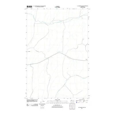
2011 Map of La Crosse East
USGS Topo · Published 2011About this map
La Crosse and its immediate rural surroundings in Whitman County are defined by the winding paths of Union Flat Creek, Willow Creek, and Mud Flat Creek. The landscape transition from the small settlement to the agricultural plateau is traced through a network of locally named thoroughfares such as Hay Lacrosse Rd and Scharrenberg Rd. East of the main town site, the Lacrosse Grange serves as a community anchor along State Route 26. The drainage patterns of the Palouse region are evident here, as ephemeral and perennial streams have carved distinct paths across the terrain, influencing the placement of original homestead access routes like Long John Morasch Rd and Union Flat Creek Rd. This survey provides a precise look at the modern rural infrastructure and land management during the early 21st century.
Find a feature on this map
16 named features on this map. Tap any name to fly to it.
Don’t see what you’re looking for? This feature index may not catch every label — zoom into the map to look around manually.
Map Details
Editions of this 2011 La Crosse East Map
This is the sole edition of this map. No revisions or reprints were ever made.
Other maps of this area

1950 · La Crosse
USGS Topo · 1:62,500

1950 · Penawawa
USGS Topo · 1:62,500

1950 · Endicott
USGS Topo · 1:62,500

1950 · Hay
USGS Topo · 1:62,500

1952 · Hay
USGS Topo · 1:62,500

1952 · La Crosse
USGS Topo · 1:62,500

1955 · Pullman
USGS Topo · 1:250,000

1958 · Pullman
USGS Topo · 1:250,000

1981 · Dusty
USGS Topo · 1:24,000
1981 · La Crosse West
USGS Topo · 1:24,000