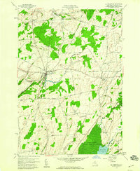
1958 Map of La Fargeville
USGS Topo · Published 1960About this map
La Fargeville serves as the central hub of this late 1950s landscape in Jefferson County, where the New York Central railroad corridor intersects the local road network. The map reveals a deeply rooted rural community organized around traditional crossroads such as Orleans Four Corners, Strough Corners, and De La Farge Corners. The terrain is defined by the prominent Beech Ridge and the winding course of the Chaumont River, which cuts through the center of the township.
Find a feature on this map
45 named features on this map. Tap any name to fly to it.
Don’t see what you’re looking for? This feature index may not catch every label — zoom into the map to look around manually.
Map Details
Editions of this 1958 La Fargeville Map
This is the sole edition of this map. No revisions or reprints were ever made.
Other maps of this area

1900 · Clayton
USGS Topo · 1:62,500

1903 · Grindstone
USGS Topo · 1:62,500

1903 · Clayton
USGS Topo · 1:62,500

1903 · Alexandria Bay
USGS Topo · 1:62,500

1903 · Theresa
USGS Topo · 1:62,500

1942 · Clayton
USGS Topo · 1:24,000
1943 · Dexter
USGS Topo · 1:31,680

1943 · Thousand Island Park
USGS Topo · 1:31,680

1943 · Redwood
USGS Topo · 1:31,680

1943 · Clayton
USGS Topo · 1:31,680