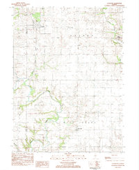
1983 Map of La Fayette
USGS Topo · Published 1984About this map
La Fayette sits at the northern edge of this agricultural landscape in Stark County, showing a traditional Midwestern grid of section roads and farmsteads in the early 1980s. The terrain is defined by the winding course of Walnut Creek, which cuts diagonally through the townships of Goshen and West Jersey. A distinct Old Railroad Grade runs southeast from La Fayette, marking the path of a former rail corridor that once linked these rural communities to the regional economy. Small family burial grounds like McClenahan Cem and Shockley Cem are preserved among the fields, offering valuable landmarks for genealogists. To the east, the western edge of Toulon appears near Indian Creek, while the southern reaches of the map include the small settlement of West Jersey, positioned near the confluence of local drainage branches.
Find a feature on this map
20 named features on this map. Tap any name to fly to it.
Don’t see what you’re looking for? This feature index may not catch every label — zoom into the map to look around manually.
Map Details
Editions of this 1983 La Fayette Map
This is the sole edition of this map. No revisions or reprints were ever made.
Other maps of this area

1931 · Galva
USGS Topo · 1:48,000

1940 · Galva
USGS Topo · 1:62,500

1941 · Maquon
USGS Topo · 1:62,500

1943 · Maquon
USGS Topo · 1:62,500

1944 · Galva
USGS Topo · 1:62,500

1944 · Kewanee
USGS Topo · 1:62,500

1944 · Elmwood
USGS Topo · 1:62,500

1948 · Elmwood
USGS Topo · 1:62,500
1953 · Galva
USGS Topo · 1:24,000

1958 · Burlington
USGS Topo · 1:250,000