
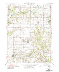
1944 Map of Elmwood
USGS Topo · Published 1967About this map
Jubilee College State Park and the surrounding agricultural townships of Peoria and Stark counties are depicted here just as the mid-century era began. This landscape is defined by its deep commitment to rural education and religious life, evidenced by the high density of one-room schoolhouses like Stringtown Sch, Moody Sch, and Whitten Sch, alongside significant local burial grounds such as Calvary Cem and Oak Hill Cem.
Find a feature on this map
67 named features on this map. Tap any name to fly to it.
Don’t see what you’re looking for? This feature index may not catch every label — zoom into the map to look around manually.
Map Details
Editions of this 1944 Elmwood Map
2 editions found
Other maps of this area

1893 · Dunlap
USGS Topo · 1:62,500

1898 · Dunlap
USGS Topo · 1:62,500

1905 · Peoria
USGS Topo · 1:62,500

1912 · Canton
USGS Topo · 1:62,500

1927 · Peoria
USGS Topo · 1:62,500

1930 · Glasford
USGS Topo · 1:62,500

1931 · Galva
USGS Topo · 1:48,000

1932 · Dunlap
USGS Topo · 1:62,500

1933 · Dunlap
USGS Topo · 1:62,500

1933 · Camp Grove
USGS Topo · 1:48,000