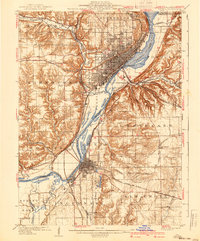
1927 Map of Peoria
USGS Topo · Published 1955About this map
Peoria serves as the industrial and transit anchor of this 1930s-era landscape, where the Illinois River widens into Peoria Lake. The river corridor is a dense tangle of infrastructure, dominated by the Peoria and Pekin Union Ry and the Illinois Terminal RR, which connected the valley's diverse industries. The presence of the State Hospital and the nearby Insane Asylum west of Bartonville highlights the era's large-scale public institutions, while landmarks like the Poor Farm and Orchard Mines reflect the region's social and extractive history. Beyond the urban centers of Pekin and East Peoria, the map reveals a rural transition into townships like Limestone and Groveland, where local landmarks such as Meyers Lake and Tenmile Creek dot the landscape near the developing Peoria Airport.
Find a feature on this map
64 named features on this map. Tap any name to fly to it.
Don’t see what you’re looking for? This feature index may not catch every label — zoom into the map to look around manually.
Map Details
Editions of this 1927 Peoria Map
This is the sole edition of this map. No revisions or reprints were ever made.
Historical Maps of Peoria Through Time
8 maps found