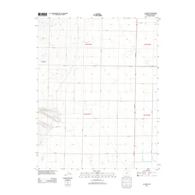
2013 Map of La Garita
USGS Topo · Published 2013About this map
La Garita serves as the focal point for this Saguache County landscape, where the San Luis Valley meets the rising terrain to the west. The area is defined by an intricate network of irrigation infrastructure essential for high-altitude agriculture, including the prominent Rio Grande Canal and the Farmers-Union-Canal. Water management is further evidenced by the McCormick Number 1 Reservoir and several laterals like the Rio Grande Lateral Number 5A that distribute water across the valley floor. Natural drainages such as Mogotas Arroyo, Carnero Cr, and La Garita Cr cut through the sections, reflecting the natural hydrology that shaped early settlement patterns. A geometric grid of rural routes, including the strikingly named Gunbarrel Rd, underscores the systematic land division and accessibility of this agricultural region in the early 21st century.
Find a feature on this map
34 named features on this map. Tap any name to fly to it.
Don’t see what you’re looking for? This feature index may not catch every label — zoom into the map to look around manually.
Map Details
Editions of this 2013 La Garita Map
This is the sole edition of this map. No revisions or reprints were ever made.
Other maps of this area

1915 · Del Norte
USGS Topo · 1:125,000

1917 · Del Norte
USGS Topo · 1:125,000

1945 · Durango
USGS Topo · 1:250,000

1953 · Durango
USGS Topo · 1:250,000

1954 · Durango
USGS Topo · 1:250,000

1961 · Durango
USGS Topo · 1:250,000

1963 · Durango
USGS Topo · 1:250,000

1964 · Sevenmile Plaza
USGS Topo · 1:24,000

1966 · Durango
USGS Topo · 1:250,000
1966 · Del Norte
USGS Topo · 1:24,000