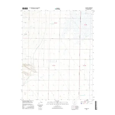
2016 Map of La Garita
USGS Topo · Published 2016About this map
La Garita serves as the focal point of this agricultural landscape in Saguache County, where a complex network of man-made waterways manages the region's aridity. The intricate irrigation system is anchored by the massive Rio Grande Canal and the Farmers Union Canal, which cut across the terrain to support local ranching and farming operations. Natural drainage features such as Mogotas Arroyo, Carnero Cr, and La Garita Cr weave through the township divisions of t42n r7e and t41n r8e, illustrating the intersection of natural hydrology and human engineering. Significant water storage is provided by the McCormick Number 1 Reservoir, while the straight path of Gunbarrel Rd defines the eastern portion of the survey. This 2016 record captures a rural Colorado community deeply tied to its water rights and the land-management patterns established by early settlers.
Find a feature on this map
34 named features on this map. Tap any name to fly to it.
Don’t see what you’re looking for? This feature index may not catch every label — zoom into the map to look around manually.
Map Details
Editions of this 2016 La Garita Map
This is the sole edition of this map. No revisions or reprints were ever made.
Other maps of this area

1915 · Del Norte
USGS Topo · 1:125,000

1917 · Del Norte
USGS Topo · 1:125,000

1945 · Durango
USGS Topo · 1:250,000

1953 · Durango
USGS Topo · 1:250,000

1954 · Durango
USGS Topo · 1:250,000

1961 · Durango
USGS Topo · 1:250,000

1963 · Durango
USGS Topo · 1:250,000

1964 · Sevenmile Plaza
USGS Topo · 1:24,000

1966 · Durango
USGS Topo · 1:250,000
1966 · Del Norte
USGS Topo · 1:24,000