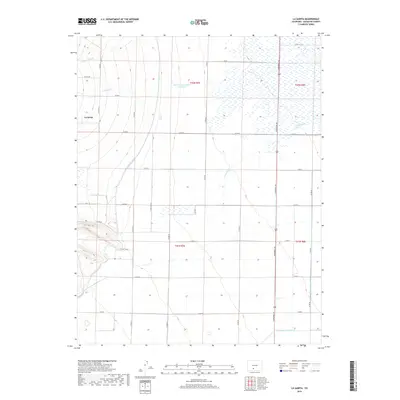
2019 Map of La Garita
USGS Topo · Published 2019About this map
La Garita sits at the base of the western mountains in Saguache County, where the desert floor meets significant agricultural engineering. This modern survey illustrates the extensive water management systems essential to the San Luis Valley, featuring major arteries like the Rio Grande Canal and the Farmers Union Canal that traverse the landscape. Natural drainage patterns including Carnero Cr, Mogotas Arroyo, and La Garita Cr are shown alongside human-made developments such as the McCormick Number 1 Reservoir. A dense grid of county roads, notably Gunbarrel Rd and Co RD G, connects the scattered farmsteads and agricultural plots, reflecting the area's continued reliance on irrigation and ranching. The map provides a clear look at the intersection of natural hydrology and the rectilinear township and range boundaries that define this part of Colorado.
Find a feature on this map
33 named features on this map. Tap any name to fly to it.
Don’t see what you’re looking for? This feature index may not catch every label — zoom into the map to look around manually.
Map Details
Editions of this 2019 La Garita Map
This is the sole edition of this map. No revisions or reprints were ever made.
Other maps of this area

1915 · Del Norte
USGS Topo · 1:125,000

1917 · Del Norte
USGS Topo · 1:125,000

1945 · Durango
USGS Topo · 1:250,000

1953 · Durango
USGS Topo · 1:250,000

1954 · Durango
USGS Topo · 1:250,000

1961 · Durango
USGS Topo · 1:250,000

1963 · Durango
USGS Topo · 1:250,000

1964 · Sevenmile Plaza
USGS Topo · 1:24,000

1966 · Durango
USGS Topo · 1:250,000
1966 · Del Norte
USGS Topo · 1:24,000