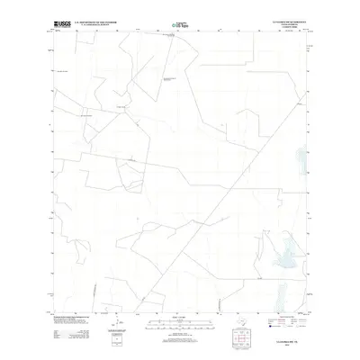
2012 Map of La Gloria SW
USGS Topo · Published 2012About this map
El Negro Ranch and a network of rural water infrastructure define this Starr County landscape in the early 21st century. The map reveals the critical importance of groundwater management in this part of South Texas, evidenced by named features such as San Ignacio Windmill Number One, San Ignacio Windmill Number Two, and the Benadito Windmill. These markers, along with the Borrachito Windmill, suggest the ongoing agricultural and ranching legacy of the region. A series of farm-to-market roads and named ranch routes, including La Morita Rd and Las Brisas Ranch Rd, provide the primary access through the open terrain. This survey provides a precise look at property boundaries and land use shortly after the turn of the millennium, documenting the scattered ranching operations that characterize the borderlands north of the Rio Grande.
Find a feature on this map
11 named features on this map. Tap any name to fly to it.
Don’t see what you’re looking for? This feature index may not catch every label — zoom into the map to look around manually.
Map Details
Editions of this 2012 La Gloria SW Map
This is the sole edition of this map. No revisions or reprints were ever made.
Other maps of this area

1938 · El Sauz
USGS Topo · 1:62,500

1938 · Sal Colorada
USGS Topo · 1:62,500

1949 · Mc Allen
USGS Topo · 1:250,000

1954 · McAllen
USGS Topo · 1:250,000

1956 · Garcias
USGS Topo · 1:62,500

1956 · Escobares
USGS Topo · 1:62,500

1957 · Mc Allen
USGS Topo · 1:250,000

1962 · McAllen
USGS Topo · 1:250,000
1965 · Camp Garcia
USGS Topo · 1:24,000
1965 · Sagunada Ranch
USGS Topo · 1:24,000