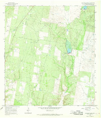
1965 Map of Sagunada Ranch
USGS Topo · Published 1968About this map
Sagunada Ranch and La Brisa Ranch anchor this mid-1960s landscape in Starr County, where the brushland of South Texas gives way to a dense network of petroleum extraction. The terrain is defined by a series of prolific energy reservoirs, including the Barbacoas Oil Field, Ross Oil Field, and the Janal Gas Field. These industrial zones are connected by numerous pipelines and access roads that crisscross the drainage of Olmitos Creek and Garcias Creek. Water management is evident through the presence of several engineered structures like Dam No 3 and Dam No 4, alongside a Flowing Well in the south. This survey illustrates the transformation of traditional ranching land into a highly developed industrial corridor, where specialized features like a Substa, Pumping Sta, and even a dedicated Landing Area support the region's energy economy.
Find a feature on this map
22 named features on this map. Tap any name to fly to it.
Don’t see what you’re looking for? This feature index may not catch every label — zoom into the map to look around manually.
Map Details
Editions of this 1965 Sagunada Ranch Map
This is the sole edition of this map. No revisions or reprints were ever made.
Other maps of this area

1938 · El Sauz
USGS Topo · 1:62,500

1938 · Sal Colorada
USGS Topo · 1:62,500

1949 · Mc Allen
USGS Topo · 1:250,000

1954 · McAllen
USGS Topo · 1:250,000

1956 · Garcias
USGS Topo · 1:62,500

1956 · Escobares
USGS Topo · 1:62,500

1957 · Mc Allen
USGS Topo · 1:250,000

1962 · McAllen
USGS Topo · 1:250,000

1965 · Rio Grande City South
USGS Topo · 1:24,000

1965 · La Grulla
USGS Topo · 1:24,000