
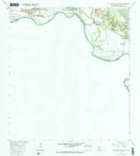
1965 Map of Rio Grande City South
USGS Topo · Published 1965About this map
The Rio Grande defines the international boundary between the United States and Mexico in this mid-1960s survey of southern Starr County. The landscape is characterized by a mix of river-bottom agriculture and an emerging energy sector, indicated by numerous Oil Wells and Gas Wells scattered across the scrubland. This section of Rio Grande City serves as a critical point of transit, featuring the Toll Bridge and U S Customs station, while the Missouri Pacific railroad tracks parallel the river's course to the northeast.
Find a feature on this map
35 named features on this map. Tap any name to fly to it.
Don’t see what you’re looking for? This feature index may not catch every label — zoom into the map to look around manually.
Map Details
Editions of this 1965 Rio Grande City South Map
2 editions found
Other maps of this area

1949 · Mc Allen
USGS Topo · 1:250,000

1954 · McAllen
USGS Topo · 1:250,000

1956 · Garcias
USGS Topo · 1:62,500

1956 · Los Ebanos
USGS Topo · 1:62,500

1956 · Escobares
USGS Topo · 1:62,500

1957 · Mc Allen
USGS Topo · 1:250,000

1962 · McAllen
USGS Topo · 1:250,000

1965 · Los Garzas
USGS Topo · 1:24,000

1965 · La Grulla
USGS Topo · 1:24,000
1965 · Sagunada Ranch
USGS Topo · 1:24,000