
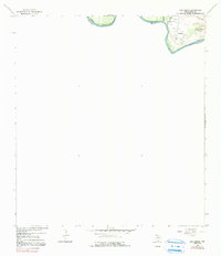
1965 Map of Los Garzas
USGS Topo · Published 1968About this map
The Rio Grande defines the northern edge of this Starr County landscape, where the international boundary between United States and Mexico shifts with the river's path. In the mid-1960s, the small settlement of Los Garzas sat near the riverbanks, supported by infrastructure like the Pumping Sta and connected by light-duty roads. The map highlights specific cultural markers such as the Los Garzas Cem and an individual Grave, offering precise locations for genealogical research in this borderlands region. To the east, Casa Banco No 90 sits near the drainage of Arroyo Quixote. The shifting nature of the river is a central theme here, as notes from the International Boundary and Water Commission indicate the boundary line was not completely defined at the time of the survey due to recent changes in the river's course between Texas and Tamaulipas.
Find a feature on this map
9 named features on this map. Tap any name to fly to it.
Don’t see what you’re looking for? This feature index may not catch every label — zoom into the map to look around manually.
Map Details
Editions of this 1965 Los Garzas Map
2 editions found
Other maps of this area

1949 · Mc Allen
USGS Topo · 1:250,000

1954 · McAllen
USGS Topo · 1:250,000

1956 · Escobares
USGS Topo · 1:62,500

1956 · Roma
USGS Topo · 1:62,500

1957 · Mc Allen
USGS Topo · 1:250,000

1962 · McAllen
USGS Topo · 1:250,000

1965 · Rio Grande City South
USGS Topo · 1:24,000
1965 · Rio Grande City North
USGS Topo · 1:24,000
1965 · Roma-Los Saenz East
USGS Topo · 1:24,000
1965 · Roma-Los Saenz West
USGS Topo · 1:24,000