
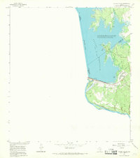
1956 Map of Roma
USGS Topo · Published 1956About this map
The Rio Grande serves as the focal point for this survey along the border between Texas and Tamaulipas, capturing a landscape defined by family ranches and river crossings. Originally surveyed by the Corps of Engineers, U.S. Army in the late 1920s and revised through 1942, the map shows the strategic and agricultural importance of the region near Roma. Notable for its record of early 20th-century life, the sheet identifies numerous family properties like Minitas Ranch and Salinas Ranch, alongside remnants of earlier eras such as the Old Army Camp and the Casa Blanca (ruins). Movement across the international boundary is marked by historic river access points, including the Los Arrieros Ford and El Fronton Ford, highlighting a time when the river was a more permeable border for local commerce and ranching.
Find a feature on this map
36 named features on this map. Tap any name to fly to it.
Don’t see what you’re looking for? This feature index may not catch every label — zoom into the map to look around manually.
Map Details
Editions of this 1956 Roma Map
This is the sole edition of this map. No revisions or reprints were ever made.
Other maps of this area

1938 · Falcon
USGS Topo · 1:62,500

1938 · El Sauz
USGS Topo · 1:62,500

1949 · Mc Allen
USGS Topo · 1:250,000

1954 · McAllen
USGS Topo · 1:250,000

1956 · Escobares
USGS Topo · 1:62,500

1957 · Mc Allen
USGS Topo · 1:250,000

1962 · McAllen
USGS Topo · 1:250,000

1965 · Los Garzas
USGS Topo · 1:24,000

1965 · Salineno
USGS Topo · 1:24,000
1965 · Falcon Village
USGS Topo · 1:24,000