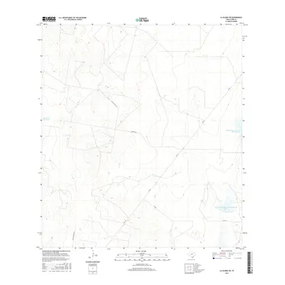
2016 Map of La Gloria SW
USGS Topo · Published 2016About this map
The south Texas scrubland and ranching territory of Starr County are defined by a network of rural roads and essential water management features. Ranching infrastructure is prominent, represented by the El Rucio Ranch Rd and the Charco del Rucio Tank, reflecting the region's historical reliance on livestock and local water sources in a semi-arid climate. The landscape also reveals mid-century agricultural planning through the presence of the Soil Conservation Service Site 1 Reservoir and Soil Conservation Service Site 2 Reservoir, which highlight federal efforts to manage runoff and support local farming operations. Primary transportation routes like Fm 755 and Fm 490 provide the main connectivity through this sparsely settled area, while private tracks such as Woods Brothers Rd and La Morita Rd reach into the back-country acreage of established family ranches.
Find a feature on this map
8 named features on this map. Tap any name to fly to it.
Don’t see what you’re looking for? This feature index may not catch every label — zoom into the map to look around manually.
Map Details
Editions of this 2016 La Gloria SW Map
This is the sole edition of this map. No revisions or reprints were ever made.
Other maps of this area

1938 · El Sauz
USGS Topo · 1:62,500

1938 · Sal Colorada
USGS Topo · 1:62,500

1949 · Mc Allen
USGS Topo · 1:250,000

1954 · McAllen
USGS Topo · 1:250,000

1956 · Garcias
USGS Topo · 1:62,500

1956 · Escobares
USGS Topo · 1:62,500

1957 · Mc Allen
USGS Topo · 1:250,000

1962 · McAllen
USGS Topo · 1:250,000
1965 · Camp Garcia
USGS Topo · 1:24,000
1965 · Sagunada Ranch
USGS Topo · 1:24,000