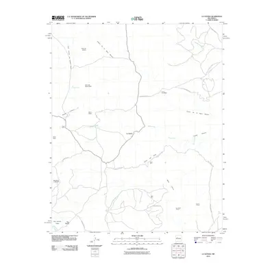
2010 Map of La Gotera
USGS Topo · Published 2010About this map
La Gotera sits at the center of this high-desert landscape in Sandoval County, where the terrain is defined by a network of drainage systems including Salada Creek and Salado Creek. The area shows a history of resource exploration, evidenced by the presence of the Betty Mine, Dorey Mine, and several mineral prospects like the Brookhaven Prospect. These industrial markers are scattered among prominent mesas and peaks such as Mesa Cocina and Cerro Chato. To the southwest, the settlements of San Antonio Valley and Dos Tristes are situated near the Cañada de San Antonio. Significant portions of the northeast and central regions fall within the Laguna Indian Res, which is accessed via the Indian Service Rd. The map also identifies the Ojo de Santa Rosa spring and the Evans Ranch, illustrating the sparse but essential water sources and livestock operations in this arid region.
Find a feature on this map
28 named features on this map. Tap any name to fly to it.
Don’t see what you’re looking for? This feature index may not catch every label — zoom into the map to look around manually.
Map Details
Editions of this 2010 La Gotera Map
This is the sole edition of this map. No revisions or reprints were ever made.
Other maps of this area

1883 · Mt. Taylor
USGS Topo · 1:250,000

1886 · Mt. Taylor
USGS Topo · 1:250,000

1892 · Mt. Taylor
USGS Topo · 1:250,000

1899 · Mt. Taylor
USGS Topo · 1:250,000

1954 · Herrera
USGS Topo · 1:24,000

1957 · Moquino
USGS Topo · 1:24,000
1957 · Arch Mesa
USGS Topo · 1:24,000

1958 · Albuquerque
USGS Topo · 1:250,000

1961 · Marquez
USGS Topo · 1:24,000

1961 · Cerro Tinaja
USGS Topo · 1:24,000