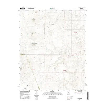
2017 Map of La Gotera
USGS Topo · Published 2017About this map
La Gotera and the surrounding high desert of Sandoval and Cibola counties are defined by a complex network of arroyos and volcanic peaks. The landscape is dominated by notable elevations such as Cerro de Jacobo and Cerro de Santa Rosa, while seasonal watercourses like Salado Cr and Cañada Salada carve through the terrain. In the southern portion of the quadrangle, the small settlements of Dos Tristes and San Antonio Valley sit near the base of the Mesita de la Madera. This map captures a rural New Mexico landscape where traditional land use and cattle ranching are supported by vital water sources like Ojo De Santa Rosa and Pino Spring. The presence of County Road 279 provides the primary transit link through this high-altitude environment, connecting isolated mesas and cañons.
Find a feature on this map
23 named features on this map. Tap any name to fly to it.
Don’t see what you’re looking for? This feature index may not catch every label — zoom into the map to look around manually.
Map Details
Editions of this 2017 La Gotera Map
This is the sole edition of this map. No revisions or reprints were ever made.
Other maps of this area

1883 · Mt. Taylor
USGS Topo · 1:250,000

1886 · Mt. Taylor
USGS Topo · 1:250,000

1892 · Mt. Taylor
USGS Topo · 1:250,000

1899 · Mt. Taylor
USGS Topo · 1:250,000

1954 · Herrera
USGS Topo · 1:24,000

1957 · Moquino
USGS Topo · 1:24,000
1957 · Arch Mesa
USGS Topo · 1:24,000

1958 · Albuquerque
USGS Topo · 1:250,000

1961 · Marquez
USGS Topo · 1:24,000

1961 · Cerro Tinaja
USGS Topo · 1:24,000