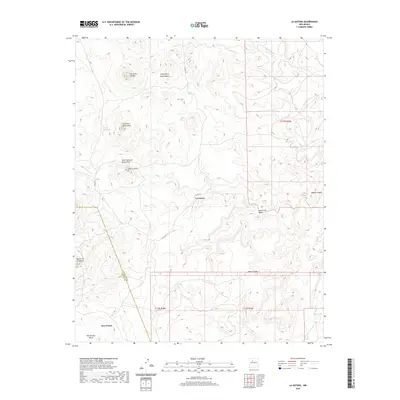
2020 Map of La Gotera
USGS Topo · Published 2020About this map
La Gotera and the neighboring small settlements of Dos Tristes and San Antonio Valley sit at the intersection of Sandoval and Cibola counties in this high-desert landscape. The area is defined by a series of dramatic volcanic and erosion-formed features, ranging from the high prominence of Cerro de Jacobo and Cerro de Santa Rosa to the broad elevations of Mesa Cocina and Mesita de la Madera. Water sources are vital but scattered in this arid environment, marked by Ojo De Santa Rosa and Pino Spring, which drain into deep incisions like Cañon del Piojo and the wider Salado Canyon. The presence of Co RD 279 provides the primary transit corridor through this network of canyons and mesas, illustrating the sparse but enduring ranching or rural footprint in this portion of New Mexico.
Find a feature on this map
22 named features on this map. Tap any name to fly to it.
Don’t see what you’re looking for? This feature index may not catch every label — zoom into the map to look around manually.
Map Details
Editions of this 2020 La Gotera Map
This is the sole edition of this map. No revisions or reprints were ever made.
Other maps of this area

1883 · Mt. Taylor
USGS Topo · 1:250,000

1886 · Mt. Taylor
USGS Topo · 1:250,000

1892 · Mt. Taylor
USGS Topo · 1:250,000

1899 · Mt. Taylor
USGS Topo · 1:250,000

1954 · Herrera
USGS Topo · 1:24,000

1957 · Moquino
USGS Topo · 1:24,000
1957 · Arch Mesa
USGS Topo · 1:24,000

1958 · Albuquerque
USGS Topo · 1:250,000

1961 · Marquez
USGS Topo · 1:24,000

1961 · Cerro Tinaja
USGS Topo · 1:24,000