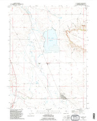
1990 Map of La Grange
USGS Topo · Published 1995About this map
La Grange serves as the primary hub of this high plains landscape, situated along the banks of Horse Creek in southern Goshen County. The town is flanked by the La Grange Cem and an industrial Pit, reflecting the local community's lifecycle and economy. To the north, the Hawk Springs Reservoir dominates the drainage basin, fed and regulated by the extensive Hawk Springs Ditch network. This water management system is essential to the ranching operations seen at Wycross Ranch and C P Ranch. The topography rises sharply in the east toward Sixtysix Mountain, a prominent mesa cut by Walker Canyon and Clay Canyon. The transition from the flat creek bottoms to the steep escarpments of The Point illustrates the geologic variety of the Wyoming plains, where narrow draws like Lovercheck Canyon provide natural breaks in the elevated terrain.
Find a feature on this map
25 named features on this map. Tap any name to fly to it.
Don’t see what you’re looking for? This feature index may not catch every label — zoom into the map to look around manually.
Map Details
Editions of this 1990 La Grange Map
This is the sole edition of this map. No revisions or reprints were ever made.
Other maps of this area

1899 · Goshen Hole
USGS Topo · 1:125,000

1954 · Cheyenne
USGS Topo · 1:250,000

1958 · Cheyenne
USGS Topo · 1:250,000

1960 · Tremain
USGS Topo · 1:24,000

1960 · Mc Compsey Pass
USGS Topo · 1:24,000

1960 · Petsch Reservoir
USGS Topo · 1:24,000

1960 · Hawk Springs
USGS Topo · 1:24,000

1960 · Kessler Gap
USGS Topo · 1:24,000

1960 · Meriden
USGS Topo · 1:24,000

1960 · La Grange
USGS Topo · 1:24,000