
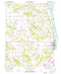
1950 Map of La Grange
USGS Topo · Published 1959About this map
La Grange and the southern edge of Canton line the Missouri bank of the Mississippi River in this mid-century survey. The landscape is defined by the winding course of the Wyaconda River and North Fabius River, which cut through the terrain toward the Mississippi. This era shows a dense network of rural infrastructure, particularly a high concentration of one-room schoolhouses like Pink Prairie Sch, Sunnyside Sch, and Porter Sch that served the surrounding agricultural townships. The Chicago Burlington and Quincy railroad follows the riverbank, anchoring the local economy alongside river-adjacent industrial sites such as a Quarry and various Gravel Pits. Local history is preserved in landmarks like Marks Memorial Cem and Wyaconda Ch, marking the spiritual and community centers of these riverfront townships before the late-century consolidation of rural districts.
Find a feature on this map
31 named features on this map. Tap any name to fly to it.
Don’t see what you’re looking for? This feature index may not catch every label — zoom into the map to look around manually.
Map Details
Editions of this 1950 La Grange Map
2 editions found
Other maps of this area

1903 · Kahoka
USGS Topo · 1:125,000

1903 · Palmyra
USGS Topo · 1:125,000

1925 · Quincy
USGS Topo · 1:62,500

1944 · Quincy
USGS Topo · 1:62,500

1945 · Quincy
USGS Topo · 1:62,500

1946 · Mendon
USGS Topo · 1:62,500

1948 · Quincy
USGS Topo · 1:250,000

1948 · Mendon
USGS Topo · 1:62,500

1949 · Durham
USGS Topo · 1:24,000

1949 · Maywood
USGS Topo · 1:24,000